AgricultureAgriculture
  • Solutions
    • Solutions
    • Workflows
      • Workflows
      • Overview
      • Land Preparation
      • Planting & Seeding
      • Crop Protection
      • Nutrient Management
      • Water Management
      • Harvest
    • Additional Solutions
      • Additional Solutions
      • Positioning Services
      • ISOBUS
      • Enterprise
  • Products
    • Products
    • Hardware
      • Hardware
      • All Hardware
      • Displays
      • Guidance Control
      • Steering Systems
      • Application Control
      • Land Forming
      • Subsurface Drainage
    • Software & Apps
      • Software & Apps
      • All Software & Apps
      • Trimble Ag Software
      • Advisor Prime
      • Data Warehouse
      • Land Forming
      • Subsurface Drainage
      • Connected Climate Exchange
    • Correction Services
      • Correction Services
      • Positioning Services
  • Partners
    • Partners
    • Developers
      • Developers
      • Ag Developer Network
      • Ag Apps
      • Software Integration APIs
      • Precision-IQ Extensions
    • Manufacturers
      • Manufacturers
      • OEMs
      • Trimble Select
    • Distributors
      • Distributors
      • Become a Reseller
  • Learn
    • Learn
    • Resources
      • Resources
      • All Resources
      • Blog
      • FAST App
      • Virtual Farm
    • Support
      • Support
      • All Support
      • Software FAQs
      • Release Notes
  • About Us
    • About Us
    • Our Company
    • Blog
    • Press Releases
    • Sustainability
  • How to Buy
AgricultureAgriculture
  • Solutions
    • WORDFLOWS

    • ADDITIONAL SOLUTIONS

    • Overview
    • Positioning Services
    • Land Preparation
    • ISOBUS
    • Planting & Seeding
    • Enterprise
    • Crop Protection
    • Nutrient Management
    • Water Management
    • Harvest
  • Products
    • HARDWARE

    • SOFTWARE & APPS

    • CORRECTION SERVICES

    • All Hardware
    • All Software & Apps
    • Positioning Services
    • Displays
    • Trimble Ag Software
    • Guidance Control
    • Advisor Prime
    • Steering Systems
    • Data Warehouse
    • Application Control
    • Land Forming
    • Land Forming
    • Subsurface Drainage
    • Subsurface Drainage
    • Connected Climate Exchange
  • Partners
    • DEVELOPERS

    • MANUFACTURERS

    • DISTRIBUTORS

    • Ag Developer Network
    • OEMs
    • Become a Reseller
    • Ag Apps
    • Trimble Select
    • Software Integration APIs
    • Precision-IQ Extensions
  • Learn
    • RESOURCES

    • SUPPORT

    • All Resources
    • All Support
    • Blog
    • Software FAQs
    • FAST App
    • Release Notes
    • Virtual Farm
  • About Us
    • Our Company
    • Blog
    • Press Releases
    • Sustainability
  • How to Buy
  1. How-to Central
  2. Search Results
  3. Manage boundary data with Field Profiler

Manage boundary data with Field Profiler

Use Field Profiler™ to manage field boundaries by crop year in Trimble Ag Software, with options to add and assign fields, draw and color-code your boundaries, import and export boundary shape files and Google Earth map files, import boundaries from the prior or following crop year, and import or export benchmarks. Our software uses spatial selection to look for matches between your data and our software, starting with the field name. If field names are different, Trimble Ag Software looks for similar field boundaries to match data for both fields.


  1. Log in to your account online (learn more)
  2. Select the preferred crop year (top left)
  3. Click on the Field tab (top menu)
  4. Select Field Profiler from the left navigation menu
  5. View the list of fields for the specified crop year, with options to search, filter or print the views selected
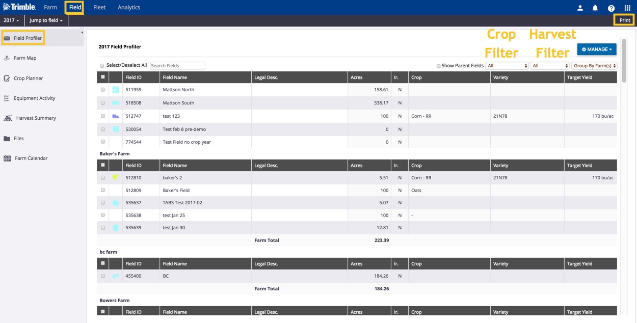
  6. Click Manage to view options
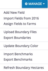
  7. Select Add New Field to add an asset to that crop year (opens the same dialogue found under Farm > Farms > Fields > Add Field)
  8. Select Assign Fields to Farms with the click of a button to organize farm assets (learn more)
  9. Select Import Fields from 2016 to automatically create a copy of field profiles from another crop year, as a clean slate for the next season’s field tasks and events (learn more)
  10. Select Upload Boundary Files to upload shape files (requires all four file types: .dbf, .prj, .shp and .shx):
    • Verify the results and confirm if the record is a new field, or select a field name from the list:
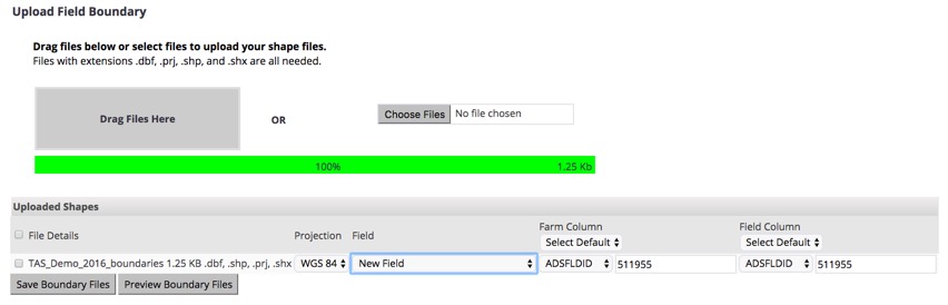
    • Select a farm column name and field column name from the list:
    • Click Preview Boundary Files to view the results
    • Click Save Boundary Files to complete the upload
  11. Select Export Boundaries for selected field(s) to download boundary map shape files:

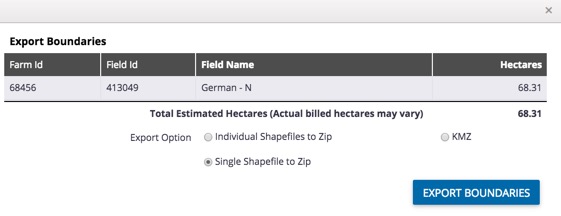
    • Click to select one of three options:
      • Individual Shape files to Zip – separate shape files for each field
      • Single Shape files to Zip – one shape file with all boundaries
      • KMZ – Google Earth/Google Map files
    • Click Export Boundaries (or click X to close the window without saving changes) to download files to your computer
  12. Select Update Boundary Color to apply custom colours to one or more selected field boundaries (learn more)
  13. Select Import Benchmarks to upload KML or KMZ (Google Earth) or GPX files with map pin locations used for field scouting or other crop management identifiers:

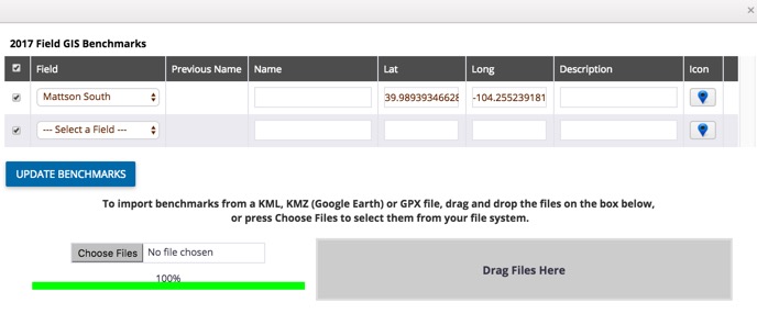
    • Customize the name, latitude and longitude coordinates or description
    • Click Icon to select a new shape or colour for the pin
    • Click Update Benchmarks
  14. Select Export Benchmarks for selected field(s) to download KML (Google Earth) files to your computer, with map pin locations used for field scouting or other crop management identifiers
  15. Select Refresh Boundary Acres to update the size of boundaries when ordering PowerZones (contact our sales team to learn more). Note: this option may show hectares, depending on your account settings.

Search How-To Central:

How-To Central Categories

Support
Get your questions answered
Authorized dealers
Locate or contact Trimble resellers
Careers
Work at Trimble
SOLUTIONS
  • Land Preparation
  • Planting & Seeding
  • Crop Protection
  • Nutrient Management
  • Water Management
  • Harvest
PRODUCTS
  • Displays
  • Guidance control
  • Steering systems
  • Flow & application control
  • Land forming
  • Subsurface drainage
  • Software
PARTNERS
  • Developers
  • Distribution
  • OEMs
  • Trimble Select
SUPPORT
  • Contact Trimble
  • Resources
  • Release Notes
  • Facebook – Trimble Agriculture logo
  • Instagram – @trimble_ag logo
  • Twitter – @trimble_ag logo
  • LinkedIn – Trimble Agriculture logo
  • YouTube – Trimble Agriculture logo
Trimble Logo
© 2022, Trimble Inc.

Trimble is an industrial technology company transforming the way the world works by delivering solutions that enable our customers to thrive. Core technologies in positioning, modeling, connectivity and data analytics connect the digital and physical worlds to improve productivity, quality, safety, transparency and sustainability. From purpose built products to enterprise lifecycle solutions, Trimble is transforming industries such as agriculture, construction, geospatial and transportation.

  • Legal
  • Terms of Use
  • Terms of Sale
  • Privacy Center
  • Do Not Sell My Information
  • English