AgricultureAgriculture
  • Solutions
    • Solutions
    • Workflows
      • Workflows
      • Overview
      • Land Preparation
      • Planting & Seeding
      • Crop Protection
      • Nutrient Management
      • Water Management
      • Harvest
    • Additional Solutions
      • Additional Solutions
      • Positioning Services
      • ISOBUS
      • Enterprise
  • Products
    • Products
    • Hardware
      • Hardware
      • All Hardware
      • Displays
      • Guidance Control
      • Steering Systems
      • Application Control
      • Land Forming
      • Subsurface Drainage
    • Software & Apps
      • Software & Apps
      • All Software & Apps
      • Trimble Ag Software
      • Advisor Prime
      • Data Warehouse
      • Land Forming
      • Subsurface Drainage
      • Connected Climate Exchange
    • Correction Services
      • Correction Services
      • Positioning Services
  • Partners
    • Partners
    • Developers
      • Developers
      • Ag Developer Network
      • Ag Apps
      • Software Integration APIs
      • Precision-IQ Extensions
    • Manufacturers
      • Manufacturers
      • OEMs
      • Trimble Select
    • Distributors
      • Distributors
      • Become a Reseller
  • Learn
    • Learn
    • Resources
      • Resources
      • All Resources
      • Blog
      • FAST App
      • Virtual Farm
    • Support
      • Support
      • All Support
      • Software FAQs
      • Release Notes
  • About Us
    • About Us
    • Our Company
    • Blog
    • Press Releases
    • Sustainability
  • How to Buy
AgricultureAgriculture
  • Solutions
    • WORDFLOWS

    • ADDITIONAL SOLUTIONS

    • Overview
    • Positioning Services
    • Land Preparation
    • ISOBUS
    • Planting & Seeding
    • Enterprise
    • Crop Protection
    • Nutrient Management
    • Water Management
    • Harvest
  • Products
    • HARDWARE

    • SOFTWARE & APPS

    • CORRECTION SERVICES

    • All Hardware
    • All Software & Apps
    • Positioning Services
    • Displays
    • Trimble Ag Software
    • Guidance Control
    • Advisor Prime
    • Steering Systems
    • Data Warehouse
    • Application Control
    • Land Forming
    • Land Forming
    • Subsurface Drainage
    • Subsurface Drainage
    • Connected Climate Exchange
  • Partners
    • DEVELOPERS

    • MANUFACTURERS

    • DISTRIBUTORS

    • Ag Developer Network
    • OEMs
    • Become a Reseller
    • Ag Apps
    • Trimble Select
    • Software Integration APIs
    • Precision-IQ Extensions
  • Learn
    • RESOURCES

    • SUPPORT

    • All Resources
    • All Support
    • Blog
    • Software FAQs
    • FAST App
    • Release Notes
    • Virtual Farm
  • About Us
    • Our Company
    • Blog
    • Press Releases
    • Sustainability
  • How to Buy
  1. How-to Central
  2. Search Results
  3. Import boundaries online

Import boundaries online

In addition to setting up basic information for your fields online, it’s easy to import field boundary data. Our software uses spatial selection to look for matches between your data and our software, starting with the field name. If field names are different, Trimble Ag Software looks for similar field boundaries to find a match.

  1. Log in to your account online (learn more)
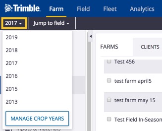
  2. Select the preferred crop year (top left) if a crop will be listed for the field
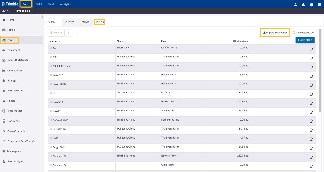
  3. Click on the Farm tab (top menu)
  4. Select Farms from the left navigation menu
  5. Click on the Fields tab
  6. Click the Import Boundaries link (top right)
  7. Click Choose File to upload files from your computer in WGS 1984 GPS coordinates with all three required formats (.shp, .dbf, .shx), as well as the optional format (.prj) for projections that are not WGS84 (WGS 1984, aka WGS84, is a geo-spatial reference system used by the National Geospatial-Intelligence Agency)
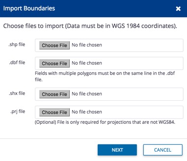
  8. Click Next (or Cancel)
  9. Click on the dropdown list next to each item to select matching column names from the .dbf file, including the Field name (required):
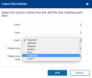
  10. Click Save (or Cancel)
  11. Scroll down the list of fields and click the edit icon  to view the field map and edit field information

Related:

  • Import fields with Field Profiler – copy profiles between crop years within your account
  • Manage boundary data with Field Profiler (note: some changes may not be reflected in fields listed on Farm menu)
  • Managing Fleet – guides for using and sharing more precision data with your vehicle displays, and from third-party accounts.


Search How-To Central:

How-To Central Categories

Support
Get your questions answered
Authorized dealers
Locate or contact Trimble resellers
Careers
Work at Trimble
SOLUTIONS
  • Land Preparation
  • Planting & Seeding
  • Crop Protection
  • Nutrient Management
  • Water Management
  • Harvest
PRODUCTS
  • Displays
  • Guidance control
  • Steering systems
  • Flow & application control
  • Land forming
  • Subsurface drainage
  • Software
PARTNERS
  • Developers
  • Distribution
  • OEMs
  • Trimble Select
SUPPORT
  • Contact Trimble
  • Resources
  • Release Notes
  • Facebook – Trimble Agriculture logo
  • Instagram – @trimble_ag logo
  • Twitter – @trimble_ag logo
  • LinkedIn – Trimble Agriculture logo
  • YouTube – Trimble Agriculture logo
Trimble Logo
© 2022, Trimble Inc.

Trimble is an industrial technology company transforming the way the world works by delivering solutions that enable our customers to thrive. Core technologies in positioning, modeling, connectivity and data analytics connect the digital and physical worlds to improve productivity, quality, safety, transparency and sustainability. From purpose built products to enterprise lifecycle solutions, Trimble is transforming industries such as agriculture, construction, geospatial and transportation.

  • Legal
  • Terms of Use
  • Terms of Sale
  • Privacy Center
  • Do Not Sell My Information
  • English